Longfellow
Nokomis
Nokomis

News for everyone, delivered to everyone
By TESHA M. CHRISTENSEN
This spring, area residents will have a new transportation option.
The state’s first Bus Rapid Transit (BRT) line will begin operating locally from the 46th St. station over to Highland Village and through the busy Snelling Ave. commercial corridor.
The “A Line” will offer a new kind of bus service that will cut the journey from 46th St. station to Rosedale Mall from 48 minutes to 35 minutes.
“It’s good for the community when we have more transit options,” observed Ward 12 City Council Member Andrew Johnson.
“It’s also going to be this great connector between the Blue Line and the Green Line,” he added.
Johnson pointed out that residents of Longfellow are closer to St. Paul’s Highland Park than the rest of Minneapolis, and do much of their shopping there. Plus, as the former Ford site is developed, the A Line will enable residents to access the area faster.
“This is going to further bridge the connection between our community and Highland Park,” said Johnson.
He believes that the increase in ridership on the A Line will benefit local businesses, and is hopeful that a tenant will move into the open space at Oak Station. “Everything is interconnected,” Johnson remarked. “When we have increased ridership numbers, the scales will tip in favor of businesses moving in that can serve the needs of the community.”
“NENA is always on the lookout for more fair and equitable transportation options available to our residents,” said Nokomis East Neighborhood Association Executive Director Becky Timm. “This new line will enable East Nokomis residents to reach their destinations quicker and provide a better experience from station to station.
“And like all transportation options in East Nokomis, NENA will continue to monitor this and work to provide a voice for any concerns or issues that may arise.”
Cross between bus and train
Bus Rapid Transit makes riding a bus a bit more like riding a light rail train.
Customers will pay their fares at ticket vending machines before boarding the bus.
By extending the curbs at stations, buses can merge more easily into traffic after serving a station. The buses won’t pull over to board passengers, but will instead remain in the right driving lane. Each A Line station is comprised of a northbound and southbound platform. All station platforms will have a customer waiting shelter with interior light and heater, as well as a pylon marker with a real-time NexTrip display.
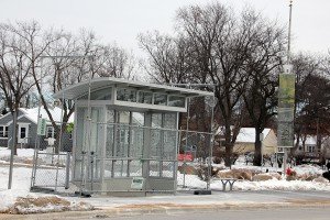 Photo left: Last year, new bus shelters were installed along the north and south sides of 46th St. in preparation for the start of A Line services this spring. A few things remain to be done before the state’s first Bus Rapid Transit line begins operating. The line will pretty much replace the current Route 84. (Photo by Tesha M. Christensen)
Passengers will be able to get on and off faster, thanks to low-floor buses and raised curbs at stations, plus wider bus doors and boarding from the front and back. These 40-foot Gillig model buses will look significantly different than regular-route buses.
The A Line buses will stop at fewer red lights courtesy of transit signal priority, and stay better in sync with traffic flow.
While people typically think that traffic is the main reason for bus delays, a traffic analysis showed that delays actually occur from stopping every block, customers paying fares, and stopping at red lights.
BRT addresses these issues.
21 stations every half-mile
 The A Line will connect the Twin Cities’ two metro light-rail lines with the busy Snelling Ave, commercial corridor and several popular destinations, including Hamline University, Macalester College, the Midway area, Highland Village, Minnehaha Park, Rosedale Center, and HarMar Mall.
Photo right: see list of actual stops at the end of this article.
The A Line will operate every 10 minutes along the 9.7-mile-long route during rush hours, midday, evenings, and weekends, with less frequent service in the early morning and late at night. The span of service will be very similar to today’s Route 84 schedule, with trips beginning at approximately 4am and continuing until approximately 1:30am
Twenty-one stations will be located roughly every half-mile.
When it begins operating, the A Line will become the primary bus route serving Snelling Ave. and Ford Pkwy. with increased service in evenings and on weekends, substantially replacing much of Route 84.
Local Route 84 will operate every 30 minutes and make off-corridor branch connections to St. Paul Ave., W. 7th St. and Davern St.
Transferring between the A Line and light rail is easy. No matter where you purchase your ticket, it will be valid for 20 hours of unlimited rides. Additionally, A Line tickets are valid for regular-route buses; present your ticket to the driver but don’t insert it into the fare box so that you can keep using it.
Why a Snelling Ave. route?
In 2011, Met Transit studied 12 high-ridership corridors and determined that BRT would perform well along the Snelling/Ford/46th route. As a bonus, it was shovel-ready.
The other routes included in the Arterial Transitway Corridors Study were: Lake St., American Blvd,, Central Ave., Chicago Ave., E. 7th St, Hennepin Ave., Nicollet Ave., Robert St., Snelling Ave., W. 7th St. and W. Broadway Ave. The study later added Penn Ave. and Chicago-Fremont in north Minneapolis.
Construction on the A Line began in 2015 with road improvements, new shelters, and other amenities. The line was originally slated to open in 2015, but a lengthy review period set the project back. It will now open in spring 2016.
The total cost of the A Line project is approximately $27 million, with money coming from the federal government ($7 million), the state of Minnesota ($16 million) and the Metropolitan Council ($4 million).
Of that, $15 million was spent constructing stations and adding related technology and fare collection elements; $7 million on new BRT vehicles for the service; $1 million on transit signal priority; and $4 million on design.
Work on stations along 46th St. was done during the Minnehaha Ave. construction project last year. What remains for 2016 is the installation of communication systems and station amenities including station furnishings, customer waiting shelters, pylon markers with real-time transit information displays and ticket vending machines.
 Future lines opening
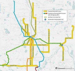
After the A Line opens, one additional line is planned to open each year as the system gets built out.
The B Line will run on W. 7th St. between downtown St. Paul, Minneapolis-St. Paul International Airport and the Mall of America. Initially scheduled to open in late 2016, the B Line project is now on hold as Ramsey County studies transit in the Riverview Corridor for future implementation.
The C Line on Penn Ave. is slated for construction and opening in 2017.
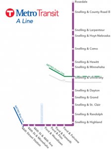
• Rosedale Transit Center (connect to many bus routes)
• Snelling & County Road B2 (connect to Route 65)
• Snelling & Larpenteur (connect to Route 61)
• Snelling & Hoyt-Nebraska
• Snelling & Como (connect to Route 3)
• Snelling & Hewitt
• Snelling & Minnehaha (connect to Route 67)
• Snelling & University (connect to Green Line, routes 16 & 21)
• Snelling & Dayton
• Snelling & Grand (connect to Route 63)
• Snelling & St. Clair (connect to Route 70)
• Snelling & Randolph (connect to Route 74)
• Snelling & Highland
• Ford & Fairview
• Ford & Kenneth (connect to many bus routes)
• Ford & Finn (connect to many bus routes)
• Ford & Woodlawn (connect to routes 23, 46 & 74)
• 46th St. & 46th Ave. (connect to Route 23)
• 46th St. & Minnehaha (connect to routes 7 & 9)
• 46th Street Station (connect to Blue Line, many bus routes)


Comments
No comments on this item Please log in to comment by clicking here