By TESHA M. CHRISTENSEN
Minnehaha Creek is getting attention in Minneapolis this year.
The first project will fix erosion problems that sprang from flooding in 2014, while the second will create a master plan for the 39 acres of parkland along the creek.
Both projects were discussed during two identical open houses in April.
FEMA repairs this fall
In 2014, the Twin Cities saw the wettest first half of the year since modern-day record keeping began in 1871, with June 2014 being the wettest month on record. Coupled with a long winter and late snowmelt, this extreme precipitation led to a record flow on Minnehaha Creek and prolonged flooding throughout most of the spring and summer, according to the Minnehaha Creek Watershed District (MCWD).
MCWD, together with the city of Minneapolis and the Minneapolis Parks and Recreation Board (MPRB), are working together to repair the erosion caused by flood damage, improve water quality, and improve access to the creek.
Thirteen places have been highlighted for work that will cost a total of $1 million. Of that, $500,000 will come from the Federal Emergency Management Agency (FEMA) and must be spent by June 2019.
Work will begin in September 2018 and be finished by June 2019.
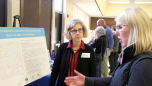
 Photo right: Citizens attended an open house on Apr. 17 open house at Lynnhurt Recreation Center to learn more about upcoming projects occurring around Minnehaha Creek. An open house was also held on Apr. 12 at the Lake Nokomis Recreation Center; both provided the same information. (Photo by Tesha M. Christensen)
The project has been divided into three areas. The first, west of 35W to Emerson, involves four sites. The second, from 35W east to Portland, has two sites in need of repair.
The remaining seven site projects are at Minnehaha Park.
The project includes a few walls constructed by the Works Progress Administration (WPA) in the 1930s that are part of the Ground Rounds historic district. The historical society will weigh in on whether to remove or fix these walls.
At Minnehaha Park, the bridge at the base of the falls was eroded by high water. Nearby, stormwater and hillside run-off damaged the trail. In other areas, a rock slab collapsed, riprap was washed away, and boardwalk was undermined.
Most of the erosion issues will be solved by installing riprap (large stones), live plant stakes, and plants to stabilize the soil, explained MCWD Project and Land Manager Tiffany Schaufler.
Throughout this process, planners have also identified 13 storm sewer outfalls that drain directly into the creek as top priorities. The MPRB and city will work to figure out the best way to filter out pollutants from these outfalls and incorporate these solutions in future work near the creek, said Schaufler. This might include rain gardens, underground storage, or other types of soil infiltration methods. The report is new, and planners are still digesting the information, she pointed out.
Master plan in the works
In the early 1900s, the Minneapolis Parks and Recreation Board began acquiring property along the Minnehaha Creek—even though the city of Minneapolis only extended to Franklin Ave. at the time and everything farther out was farmland.
Under the direction of Theodore Wirth in the 1920s and 1930s, the creek was straightened in many places, and the parkway/carriageway installed.
 Photo left: Lisa Goodard of Minneapolis Public Works chats with Nokomis resident Teresa Miller during the Apr. 17 open house. Miller is keeping a close eye on water issues in the area, concerned because of the perpetual flooding in her backyard that is adjacent to Solomon Park. (Photo by Tesha M. Christensen)
In the 1960s and 1970s, the Eckbo Plan guided improvements along the creek. The roadway was paved its signature pink, and bicycle and walking trails separated. The pedestrian bridges were built in 1978.
“Since then, no master planning has been done,” pointed out MPRB Project Manager Adam Arvidson. “We’re overdue.”
He’s leading a comprehensive look at the parkland to fashion a master plan that looks ahead 20-30 years.
A Community Action Committee (CAC) is in the process of being formed and will begin meeting soon. A plan is expected to be created and approved by the MPRB of commissioners in January 2019.
Among the questions raised are whether MPRB should extend its system of trails all the way west of Lynnhurst Park to the city line. Right now, the trails head north at the parkway to Lake Harriet and do not extend any farther west.
Another question is whether more canoe launches should be added. Currently, there is one near Lyndhurst, one at Lake Nokomis, and one proposed for Lake Hiawatha.
Public input was solicited at two open houses in April, and a survey is available online at the MPRB project website to collect comments. Citizens can also sign up to receive project updates.
Comments
No comments on this item Please log in to comment by clicking here