Longfellow
Nokomis
Nokomis

News for everyone, delivered to everyone
New plan will provide a 20-30-year vision for Minnehaha Creek
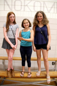 Left to right, Lucia Luepker, age 12, Josie Bures, age 10, and Libby Bures, age 13, ask that the meadow near their houses be left undeveloped so they can continue to play there. "We live in our meadow," J. Bures said on behalf of the trio, adding that the loss of it would have a big impact on their childhood. (Photo by Tesha M. Christensen)[/caption]
 By TESHA M. CHRISTENSEN
tesha@longfellownokomismessenger.com
Bike trails, pickleball courts, ADA-accessible launching pads, storywalks, and pollinator gardens are part of a 20-30-year vision for the park land along the five miles of Minnehaha Creek that cut across the southern part of Minneapolis.
The area has been broken down into four sections, and preferred concept plans for each segment have been released to the public and the 19 members of the Community Advisory Committee (CAC).
During a meeting at Nokomis Recreation Center on Thursday, June 13, 2019, MPRB Planner Adam Arvidson stated, “This project is not yet complete and this is not the last opportunity to have your voice be heard. Tonight we’re trying to get the pulse of where we stand.”
Planners did community engagement in the parks last summer, and held several community open houses during the winter in order to solicit ideas and feedback. These were then incorporated into these preferred concepts presented at the sixth CAC meeting, and additional ones are expected before a final draft is passed onto the park board for review and a public hearing.
The master plan will cover the creek, trails, trees, roads, recreation amenities, and all else contained within park board land between the Edina border and Minnehaha Falls.
Arvidson pointed out that the MPRB, city of Minneapolis and Minnehaha Creek Watershed District have given feedback on the plans as they develop.
“We’re trying to make sure that these three public agencies that you pay for are moving forward together,” said Arvidson.
Safer crossings for peds, bikers
The majority of comments MPRB is receiving right now about the plan have to do with the park road that runs the length of the creek. (See related story starting on front page.)
Segment three, from east of Interstate 35W to Cedar, includes ways to make things safer for pedestrian and bikers. In fact, there are more crossings here than in any other segment of the plan.
Options to improve crossings include high visibility crosswalks with raised pedestrian pads, and a tunnel underneath Cedar Ave. Although the tunnel would be lower than the creek, planners are confident that they can design it in a way to keep it dry, as has been done elsewhere
The majority of comments received during the planning process so far have revolved around the Portland/50th/Parkway area, and the plan would straighten intersections and place improvements at 50th, Portland and Park.
Planners are also trying to balance the needs to slower bicyclists with faster ones and will add additional trails in some areas.
Water and flooding issues
Planners have also been working to increase flood storage capacity in the creek and slow the water down to prevent damage. The areas identified for stormwater BMPs (best management practices) take into account the city’s stormwater outfalls as well as existing problem areas, according to Arvidson.
In segment four, the creek right now is very straight, and the plan would add more curves to increase flood capacity and storage.
In response to a concern voiced at the meeting about the ducks and geese in the area, Arvidson pointed out that habitat will be better than it is now.
A few stormwater BMPs would also be added in this section, with a large one underground in what is now a large field of 34th that is often damp. The installation of the BMP means that the area would be drier than it is now, Arvidson said.
Another large one is planned for the field in the southwest intersection of Cedar and the Parkway which typically floods.
On behalf of the Nokomis Hiawatha Water Sustainability grassroots group, Joan Soholt talked about water issues in the neighborhood, and the number of people with water in their basements and broken pipes. “We are asking for more comprehensive studies,” said Soholt, done by the University of Minnesota or United States Geological Survey.
“We feel like the park board is moving too fast with this,” stated Soholt.
#1: Edina to Lynnhurst
>> This section of the creek would remain wild without paved trails as it is today.
>> An overlook on the Penn Ave. bridge would be added.
>> The existing Lynnhurst Recreation Center building would be torn down, and a larger structure built on the north side of 50th. It would focus on the local environment and creek.
>> The tributary that pours south from Lake Harriet would be “daylighted,” and the pipe it currently flows would be removed so that it is accessible again.
>> A bridge would be built on 50th for traffic to cross this tributary, and bikers and pedestrians would cross underneath it.
#2: Lynnhurst to 35W
>> As requested by residents, the trails will stay in the gorge. A braided channel restoration approach may be used.
>> Trails under Lyndale Bridge will be widened.
>> The section of roadway under Nicollet Bridge will be closed and picnic area, rest-rooms, art, adventure play, parking lot, creek access and more added.
#3: 35W to Cedar
>> Two areas with single track bike trails of varying skill levels will be added near Bloomington. Two tennis courts will stay.
>> A redundant section of roadway south of the gas station at Cedar will be removed and a stormwater BMP added. South of the parkway where it typically floods, another stormwater BMP will be installed.
>> A tunnel will transport bikers and pedestrians safely under Cedar Ave.
>> Stormwater BMPs will be installed at several locations along with creek restoration and remeandering.
>> The area around Portland and 50th will be realigned, and some sections made one-ways to discourage thorough traffic.
* Note: The section from Cedar to Lake Hiawatha is included within the Nokomis-Hiawatha Regional Park plan.
#4: Lake Hiawatha to Minnehaha Falls
>> A tunnel will provide safe crossing under 28th. (This will be built this summer when the 28th bridge is replaced.)
>> The tennis courts at 30th will become a pollinator garden, and those at 32nd fixed up. The courts at 34th will be converted in a bike skills park.
>> Underground flood storage with pollinator gardens and open space would be added on the east side of 34th.
>> Many parts of the creek between bridges will be remeandered to slow down water and provide more capacity storage. Several BMPs will be installed.
>> An ADA takeout will be positioned before the falls.
>> The green space in the boulevard would have a storywalk with natural plantings and public art along a natural surface trail.


Comments
No comments on this item Please log in to comment by clicking here