Longfellow
Nokomis
Nokomis

News for everyone, delivered to everyone
By TESHA M. CHRISTENSEN
Local residents are helping decide what the new S. 28th Ave. bridge will look like over Minnehaha Creek.
The feedback gathered during a public meeting on May 30 was that neighbors want to see a curved façade design with enhanced concrete cutouts.
People also prefer a design without a pillar separating the trail from the creek. This will provide better sight lines to the creek for trail users, and replicate the existing historic structure. Plus, a one-span bridge will have less impact on the park during construction.
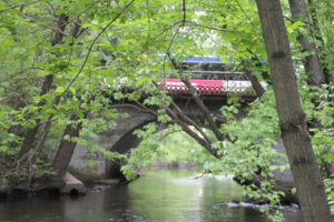 Photo right: When the new bridge is completed in 2019, trail users will cross under the busy S. 28th Ave. roadway along Minnehaha Creek. (Photo by Tesha M. Christensen)
There was a discussion about railings, but this element will be determined further along in the design process. However, the bridge railings used at the Burnham Road Bridge near Lake of the Isles were well received by historians. The original railings on the bridge were concrete but will be replaced with metal ones.
While the existing bridge is an arch, the new one has to be square to accommodate the trail underneath the roadway and the house to the south, explained City Bridge Engineer Jack Yuzna.
Top priority to move trail beneath the road
Moving the trail beneath the busy S. 28th Ave. bridge is a top priority of users. This intersection was highlighted in the Nokomis-Hiawatha Regional Master Plan, and a trail crossing below the bridge ranked as the second most important priority for the entire park.
Citizens at a May 9 open house on the project reiterated the danger of crossing S. 28th Ave. as it is now with a skewed trail alignment.
This trail is a component of the Grand Rounds National Scenic Byway that has been nominated for inclusion on the National Register of Historic Places, and so the bridge needs to complement the historic setting as well as the natural setting, pointed out Yuzna.
“It’s a community amenity,” stated Yunza.
The original bridge was constructed in 1904 when vehicles and pedestrians shared the roadway. The arch has a clear span of 25 feet and rise of 7 feet. In the 1920s, the iron railing from the Franklin Ave. bridge was installed on the 28th Ave. bridge and sidewalks were added by cantilevering 3.5 feet beyond the bridge’s spandrel walls.
 Photo left: While the new bridge will take up the same space as the old one, the configuration will be different. The driving lanes on the new bridge will be more narrow while the sidewalks will be wider. (Graphic submitted)
The existing structure has narrow sidewalks of 4.5 feet wide. In the new design, there will be 10 feet on each side to make it more comfortable for pedestrians and easier to remove snow. Approaching the bridge there will be eight-foot sidewalks with 6 feet of green space between the sidewalk and the street.
When the new bridge is constructed, the street lanes will be narrowed to make a shorter crossing for pedestrians, explained Public Works employee Patty Day.
Lanes are currently 22 feet and will be 16 feet in the future. The bridge will remain 56 feet wide.
There will also be new ADA-compliant crossings at E. 47th St.
Bridge will be out for six months in 2019
While the work is underway, S. 28th Ave. will be closed to vehicles and pedestrians for about six months. Residents didn’t favor using Nokomis Ave. as a detour route, so S. 34th Ave. will be the designated route for vehicles. This will be coordinated with the 34th Ave. reconstruction project from E. Minnehaha Pkwy. to E. 58th St., as well as Metro Transit.
Trail users will be directed up a block to E. 46th St.
The 28th bridge work is expected to begin in April 2019 and be finished in November 2019.
During that time, the disruption to flora and fauna will be minimized.
“The engineering team is working closely with the neighbors immediately impacted by the project and have made adjustments based on that feedback,” said Day. “Engineers are also working closely with the Minneapolis Park and Recreation Board to ensure that the design of the pedestrian and bike trail is consistent with the long-range plan for the Nokomis-Hiawatha Regional Park.”
The proposed layout will be shared next with the Bicycle Advisory Committee and the Pedestrian Advisory Committee. It will then be brought before the Transportation and Public Works Committee of City Council in July 2018.


Comments
No comments on this item Please log in to comment by clicking here