Longfellow
Nokomis
Nokomis

News for everyone, delivered to everyone
By TESHA M. CHRISTENSEN
Will a new transit line connect South Minneapolis with downtown St. Paul in the near future?
The proposed Riverview Corridor transportation route would run 12-miles from St. Paul’s Union Depot to Minneapolis-St. Paul International Airport and the Mall of America.
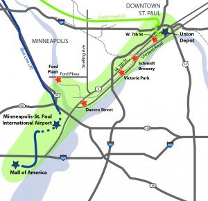 Photo right: The proposed Riverview Corridor transportation route would run 12-miles from St. Paul’s Union Depot to Minneapolis-St. Paul International Airport and the Mall of America. One possible route takes riders from the Union Station past the Xcel Center, down West 7th St., jogging over to the former Ford plant site in Highland Park, across the Ford Parkway bridge and to the 46th St. station before heading down to the airport and mall. (Photo submitted)
One possible route takes riders from the Union Station past the Xcel Center, down West 7th St., jogging over to the former Ford plant site in Highland Park, across the Ford Parkway bridge and to the 46th St. station before heading down to the airport and mall.
Another option is using Highway 5 instead of going through Highland Park or building a new river crossing.
“The goal of the Riverview Corridor is to create a new connection between downtown St. Paul and the airport, improving transit and stimulating development along the way,” remarked Ward 12 Council Member Andrew Johnson.
 Photo left: The Ford Parkway bridge may be the best place for the Riverview Corridor to cross the Mississippi River and also connect with the Blue line. “Longfellow is closer to Highland Park than much of Minneapolis, so not only could the Riverview Corridor better connect us with the great neighborhood across the bridge, but it also helps position the Ford Plant site to emerge as a thriving town square with great shopping, dining, entertainment, and recreation options that are just minutes away,” said Ward 12 Council Member Andrew Johnson. (Photo by Tesha M. Christensen)
Johnson pointed out that the route will need to cross the river somewhere, and the options to do so are down to Highway 5 or the Ford Parkway bridge, each having advantages and disadvantages.
“While the Ford Parkway bridge would add additional transit time to the route, it also maximizes the development potential of the 135-acre Ford Plant site and avoids some logistical difficulties associated with using Highway 5,” said Johnson.
Spring 2017 new deadline date
The Ramsey County Regional Rail Authority launched the latest study of the corridor in July 2014, the fifth since 1998. Three committees have been collecting and analyzing data on modes and routes, of what is often called the third leg of a transit triangle, the others being the Blue Line in Minneapolis and the Green Line in St. Paul.
Planners have reduced the options to three: West 7th, the Canadian Pacific Spur Line that runs a few blocks south of West 7th, or a combination of the two.
Businesses along West 7th have been concerned about the potential loss of parking and lanes there.
The Policy Advisory Committee expected to select an option by spring 2017.
The project would then need to be adopted by several government bodies and funding secured. A new transit service could take up to 12 years to design and construct.
Light rail, Bus Rapid Transit or streetcar?
Possible modes include light rail, bus rapid transit, streetcars or a hybrid option.
Johnson’s preference for this route is a streetcar line. “Streetcars feel like light rail, but are significantly less expensive and don’t eliminate a lane of traffic,” he pointed out. “Yet unlike Bus Rapid Transit, the permanent infrastructure stimulates economic development. The latter is particularly important for the future of the Ford Plant site, which has the potential to become the extension of, and complement to, Highland Park.”
When the Godfrey Parkway bridge is replaced next year, the new bridge will be capable of supporting LRT or streetcars.
How would a streetcar cross Hiawatha without making traffic worse?
The biggest issue for Ward 12, according to Johnson, is how a streetcar will cross Hiawatha Ave. and the interchange at the 46th Street Station without making the traffic flow worse.
“The good news,” Johnson said, “is that this project may very well be the way we get Metro Transit to approve the use of ‘rail obstruction’ sensors. They would eliminate the need for the ‘clearing phase’ that occurs today, where an oncoming Blue Line train overrides the traffic signals to give eastbound traffic a green light even if they just had one.”
“The need to ensure that no vehicles are obstructing the tracks when a train comes is critically important, but the current method is terribly inefficient and disruptive to the overall flow of traffic,” Johnson noted. “A win-win would be using the Riverview Corridor project to secure this traffic flow improvement for Hiawatha.”
He is excited by how this line would connect South Minneapolis with its neighbor right across the river.
“Longfellow is closer to Highland Park than much of Minneapolis,” Johnson added, “so not only could the Riverview Corridor better connect us with the great neighborhood across the bridge, but it also helps position the Ford Plant site to emerge as a thriving town square with great shopping, dining, entertainment, and recreation options that are just minutes away.”
Existing bus not adequate
The bus line #54 currently travels between Union Depot and the Mall of America taking West 7th and Highway 5, making the trip in about 40 minutes. Officials say it is often crowded and inadequate for the corridor.
By the year 2040, the population in the corridor is expected to grow by 63% and employment by 33%, making this highly traveled corridor more difficult to travel in years to come.
Proponents say transit improvements would increase mobility, and support community and regional economic development goals.
The many people without a car in the area would also benefit. The percentage of households without an automobile in the Riverview Corridor study area is near twice that of households in Ramsey County as a whole.
Meetings planned
Upcoming meetings are being planned for the Longfellow neighborhood, but have not yet been scheduled. According to Johnson, the project team will soon be reaching out to Longfellow to engage the neighborhood and get feedback on the proposed route.
“This line will help connect residents with jobs and amenities on the other side of the river, provide a great transit route to downtown Saint Paul, and even help stimulate economic development on the east side of the 46th Street Station,” said Johnson.
To sign up for project updates, go to http://riverviewcorridor.com.


Comments
No comments on this item Please log in to comment by clicking here