Longfellow
Nokomis
Nokomis

News for everyone, delivered to everyone
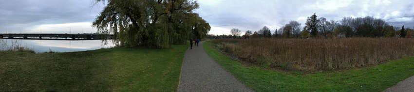
 These images show the same area on the west side of Lake Nokomis in 2014 and in 2017. On left is an image taken by Amy Stabala, who lives on W. Lake Nokomis Pkwy. of her children flying kites in the park. This is what the park land in that area looked like from at least the 1930s to 2014. This same area is now too wet to mow, as shown in the second photo (above) of Monica McNaughton walking on the path on the west side of Lake Nokomis near the Knoll and Amelia holding/retention ponds. Invasive cattails have taken over the area that was once mowed turf, and standing water is between the path and the cattails. (Photos submitted)
Basements are flooding, backyards are under water, sinkholes are developing, and sewer lines are breaking around Nokomis and Hiawatha lakes.
Residents are concerned, and they’re asking why.
They also notice that there’s a lot of standing water throughout the year around Lake Nokomis, and lake levels at Nokomis and Hiawatha are higher than they used to be.
Joan Soholt and Monica McNaughton are trying to fit the puzzle pieces together and look at more than just the impact on city infrastructure, resident’s homes, the Hiawatha Golf Course, and Lake Nokomis shoreland.
The two women are leading a group of neighbors who share information and ask questions concerning ground and surface water infiltration in the lower Minnehaha Creek subwatershed. The Nokomis/Hiawatha Water Sustainability group also hosted a meeting in March to pull together residents, politicians, and experts; this grassroots meeting was attended by over 100 people.
“We have many concerns that the planning being done by the Minnehaha Creek Watershed District (MCWD) and the Minneapolis Parks and Recreation Board (MPRB) does not have enough scientific evidence behind it to guarantee homeowners and taxpayers that properties will not continue to be adversely affected by water that has been modified to flow into the creek, lakes, and ponds,” said Soholt.
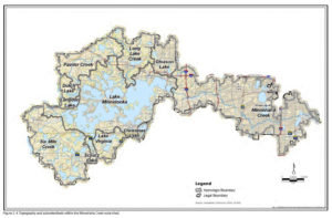 Illustration left: Lake Nokomis and Lake Hiawatha are at the end of a large watershed that begins around Lake Minnetonka and drains via Minnehaha Creek towards the Mississippi River. Nokomis/Hiawatha Water Sustainability is pushing for the United States Geological Survey to conduct a comprehensive and unbiased study of the region to learn what’s driving the water problems in South Minneapolis. (Click on image for larger display)
“Promised maintenance and upkeep has not been done possibly adding to the increase in ground and surface water. An example of this would be the increase in cattails around Lake Nokomis that may be holding water in rather than helping absorb it.
She added, “We are also concerned that with increased precipitation our community is not in a position to handle more water because of modifications that have been made to the creek and lake system.”
Soholt and McNaughton have proposed bringing in the United States Geological Survey (USGS), a federal scientific agency that provides unbiased, accurate and consistent research to study the issue in depth. (They have also been involved in the water issues surrounding White Bear Lake.)
The Minnesota Department of Natural Resources is currently deciding what the scope of the project should be, and will progress from there, according to District 63B Representative Jean Wagenius, who lives a couple of blocks north of Minnehaha Creek in the Northrup neighborhood.
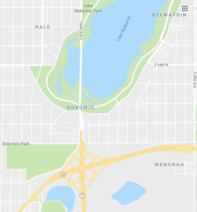 Image right: Changes in the Richfield area, as well as around Lake Nokomis, have contributed to an increase in surface water run-off around Lake Nokomis. Shown here in this Google Map are Taft (bottom left) and Mother (bottom right) lakes, which have both risen, as well as Solomon Park, which is under water. The three water retention ponds around the south and west of Lake Nokomis are also visible.
Soholt is concerned that the scope will be too narrow and focused merely on Lake Nokomis instead of the entire Minnehaha Creek watershed. They have approached the DNR, Hennepin County, Met Council, Minnehaha Creek Watershed, and local officials to help secure funding for a USGS study of the larger Minnehaha Creek watershed.
“Until a comprehensive study is completed, water management projects affecting our area should be delayed,” said McNaughton. “This includes any planning or action to fill the floodplain at Hiawatha Golf Course. No entity in the discussion has enough data to assure homeowners around Lake Hiawatha and the Hiawatha Golf Course that what has occurred around Lake Nokomis will not occur if changes are made to water management in their area.”
What’s the problem?
In 2014, the city resurfaced Soholt’s street, and subsequently, eight houses on her block experienced sewer breaks. Soholt started asking questions and has now collected information on over 80 homes that have dealt with sewer line breaks, sinkholes developing under their basement floors, sinking foundations, standing water, and more. Repairs have cost homeowners between $5,000 and $60,000.
Homeowners whose backyards abut Solomon Park near Highway 62 have lost half their yards to standing water in the past three years, and now have to purchase flood insurance. Plus 100-year-old trees are dying.
Following the installation of retention ponds to help mitigate the water on the west and south of Lake Nokomis, basement floors began to collapse. A sinkhole developed in Nokomis Pkwy. near the Amelia water retention pond. One day emergency trucks arrived because it was affecting a gas line, Soholt recalled.
McNaughton is particularly concerned about the standing water she’s observed in three areas: the west side of Lake Nokomis (known by many as the Lagoon) between the two holding/retention ponds known as the Knoll and Amelia ponds; the southwest end of the Cedar Ave. bridge that goes over Lake Nokomis; and the area east of the Gateway Pond near Derby Ave.
“Historically, these areas were dry most of the summer and fall,” said McNaughton, but now they’re full of invasive cattails.
McNaughton is also worried about uncharacteristically high groundwater levels, which she’s seen increasing for the past four years.
Since 2014, over ten sewer connections have been repaired between 54th St. and 58th St. and 12th Ave. and Edgewater Blvd. In the summer of 2017, dewatering on Edgewater Boulevard took six weeks before sanitary sewer repairs could be started, she pointed out.
The city of Minneapolis did not have any groundwater monitoring wells in the Nokomis area until two monitoring wells were installed last fall.
“The absence of historical data has made it difficult for the city to identify the triggers that are exacerbating the problems in the area,” observed McNaughton.
What’s causing these issues
“Many argue that the problem began in 2014 after the significant June rain event,” said McNaughton. “However, we have seen significant changes in the area since the late 1990s.”
In addition to draining the neighborhoods directly around Lake Nokomis and Lake Hiawatha, water is also coming from the airport and Richfield. Plus, storm sewer lines in Minneapolis drain an area that stretches all the way up to Lake St. into Lake Hiawatha.
Specific changes in the area that have affected surface runoff (that becomes groundwater) include:
• The closing of Rich Acres golf course (permeable soil) on the east side of Cedar Ave., south of Hwy 62.
• Completion of the North-South Runway at the Minneapolis-St. Paul Airport, and significant building of air freight and airport facilities (nonpermeable soil)
• Development of Richfield Commons (Target/Home Depot). Previously, this area was composed of single-family residences that had significantly more permeable soil.
• Minnehaha Creek Watershed District water quality projects at Legion Lake (Veterans Park)
• Expansion of 35W/Crosstown Interchange
• Building and completion of the holding/retention ponds at Lake Nokomis – Knoll, Amelia, and Gateway
• Management former MAC property now known as Solomon Park taken over by MPRB
• Building and of the weir (low dam) at Lake Nokomis completed around 2000 and rebuilt/redesigned in 2012
Additionally, since Grey’s Bay Dam in Minnetonka was replaced, the level of Lake Hiawatha has been much higher, pointed out Jerry Mullen who lives across the street from the Hiawatha Golf Course. While there is a weir separating Lake Nokomis from Minnehaha Creek, the creek flows directly in and out of Lake Hiawatha. From the 1940s to the 1970s, Lake Hiawatha’s water level ranged from 810.5 to just shy of 812. From the 1990s to the present, the lake levels have ranged from 812.5 to shy of 813.
“Groves of mature trees are dying in Solomon’s Park and Mother Lake. Neighbors tell me that until now, nothing like this has happened in the memory of folks who have lived in the area for over 40 years,” wrote Wagenius in a letter to the DNR in December 2017.
She also pointed out that the weir at Lake Nokomis is several feet higher than the level of Minnehaha Creek, which prevents Lake Nokomis water from freely flowing out of the lake and keeps water levels high. Beachfront has been lost on the lake, and mature trees are dying.
Nokomis/Hiawatha Water Sustainability is pushing for the level of Lake Nokomis managed to rarely be above its Ordinary High Water level elevation of 815.4 feet.
Water best management practices have evolved, pointed out Wagenius.
“Now instead of moving water off the land as quickly as possible, best management calls for slowing water down to protect surface waters and recharge groundwater resources. Both are important,” she said. “Recharging drinking water aquifers is especially important in the Minnehaha Creek watershed since aquifers upstream from Minneapolis are showing stress. Slowing water down should have multiple benefits, not just for those downstream but for those upstream especially since DNR must ensure sustainability when permitting wells including drinking water wells.”
What can you do?
Nokomis/Hiawatha Water Sustainability urges residents to follow the group on Facebook, Twitter, and Instagram to stay updated.
People are also encouraged to contact their city council members (Jeremy Schroeder in Ward 11 and Andrew Johnson in Ward 12) and ask that the city support the USGS study, ensure the DNR’s leadership in managing the entities involved, and move aggressively to identify and implement solutions in both the short and long-term to protect homes, infrastructure and parks.


Comments
No comments on this item Please log in to comment by clicking here